Page 7 of 11
Scenic Waitsfield/Warren loop
Posted: Wed Oct 13, 2010 12:05 pm
by Aspen
From Route 100 in Waitsfield
Turn onto Bragg Hill Road
At fork in road at end of Bragg Hill Road bear left onto
Number 9 Road to Route 17
Right onto Route 17
Left onto German Flats Road
Right turn off German Flats and drive up to Mount Ellen
Return from Mt. Ellen to German Flats; make a right turn onto German Flats
End of German Flats Road turn right onto Sugarbush Access Road which will take you to the Sugarbush Lincoln Ski Resort
Return to Route 100 down scenic Inferno Road or Sugarbush Access Road
Reverse above driving routes, depending on where you are located on Route 100 in Waitsfield or (Sugarbush Access Road) off Route 100 in Warren.
If nearby, recommend driving this loop several times in different directions.
Add to your future Vermont Foliage itineraries.
Aspen
Re:Sugarbush (Maple Syrup) Farm directions
Posted: Thu Sep 22, 2011 4:11 pm
by Aspen
If in or nearby Woodstock, Sugarbush Farm is an educational place to visit to learn how maple syrup is made, tour the Sugar House and take a self guided tour among the maple trees to see how maple sap is drawn from the trees.
Sugarbush Farm has outstanding maple syrup and cheese to sample and purchase.
Google Sugarbush Farm Woodstock, Vermont for an assortment of information and directions.
Directions to Sugarbush Farm in Woodstock, Vermont may be found at this website:
http://www.sugarbushfarm.com
Click on Visit the Farm
On Drop down, click on
Hours & Directions
Aspen
Re: GREAT VERMONT DRIVING ROUTES
Posted: Fri Sep 23, 2011 2:11 pm
by Andy
New_to_USA: As always, the answer depends. While NEK is known to peak earlier than Southern parts of the State, it is not consistently true. For example, I have found nice color in Peacham later every year I have been there. Last year, while parts of the state had already peaked (including some of the Southern venues), we found great color up in Barton. So, I would encourage you about your dates. I think you are likely to find some good color up there at that time.
Re: GREAT VERMONT DRIVING ROUTES
Posted: Sat Sep 24, 2011 5:21 am
by ctyanky
Carol: You are correct. We didn't drive the German Flats Road. I don't know why I didn't include that in our itinerary. I had driven the road a few years ago to go on the Sugarbush ski lift foliage ride with friends. I think the Common Man Restaurant is around there too. You know the old saying, "So much to do, so little time!". But Bragg Hill is definately one of the most beautiful roads in Vermont! I'll probably be there again next weekend with Phil and bm.
Hope you get to go on the GF's loop in the future!
Re: GREAT VERMONT DRIVING ROUTES
Posted: Sat Sep 24, 2011 4:44 pm
by new_to_USA
Hello Andy,
I think you had responded to my last year post here..

anyways i have planned my trip for this year for Oct 1st week end and staying at Jeffersonville. Based on the so many good advices, plans, suggestions provided in this forum, i have planned couple of drives like Route 100,108, Jaypeak, Hazen Notch, Montogemy center, etc.. Hoping to see very good colors... will that week end be peak or i will just get to see some colors? Am i too early to these places?
You guys are rocking by providing so much information here... Lucky Vermonters who can plan their trip any time and not miss the colors
Regards,
Ranjana.
Re: GREAT VERMONT DRIVING ROUTES
Posted: Sat Sep 24, 2011 8:07 pm
by Andy
Ranjana: As many have stated on the various threads here, it will likely vary from place to place. The higher elevations will turn earlier as will those areas East of Lake Champlain. In Jeffersonville you are right at the base of Smugglers' Notch. You are virtually certain to find some nice color there at that time. Likewise, Jay Peak and Hazen's notch. "Peak" color is in the eye of the beholder. Some see it as all leaves in total color. Others see it differently. I am sure you won't be dissappointed.
Re: GREAT VERMONT DRIVING ROUTES
Posted: Sat Sep 24, 2011 8:39 pm
by new_to_USA
Thanks Andy, i have included the smuggler's notch for sure
Re: Scenic Waitsfield/Warren loop
Posted: Sun Sep 25, 2011 12:31 am
by Aspen
Aspen wrote:From Route 100 in Waitsfield
Turn onto Bragg Hill Road
At fork in road at end of Bragg Hill Road bear left onto
Number 9 Road to Route 17
Right onto Route 17
----->
Left onto German Flats Road
Right turn off German Flats and drive up to Mount Ellen
Return from Mt. Ellen to German Flats; make a right turn onto German Flats
End of German Flats Road turn right onto Sugarbush Access Road which will take you to the Sugarbush Lincoln Ski Resort
Return to Route 100 down scenic Inferno Road or Sugarbush Access Road
Reverse above driving routes, depending on where you are located on Route 100 in Waitsfield or (Sugarbush Access Road) off Route 100 in Warren.
If nearby, recommend driving this loop several times in different directions.
----->To extend this drive, when on Route 17, continue driving straight up Route 17, pass Mad River Glen base to the trailhead parking area for the Long Trail. Enjoy the view across Champlain Valley. Turn car around at parking lot and return back down Route 17; passing Mad River Glen base again. Make a right turn onto German Flats Road then proceed with the rest of the Waitsfield/Warren loop as directed.
Aspen
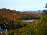
VERMONT PONDS AND LAKES
Posted: Tue Sep 27, 2011 6:00 pm
by Snookman2
I've read a lot of old threads and seen a bunch of these different lake and pond names thrown around...Willoughby, Island, Lewis, etc. I thought a thread specifically about this subject might be useful. Which ones are your favorites and why? What's special about them. etc.?
Re: NEK (or other areas) ponds and lakes
Posted: Tue Sep 27, 2011 8:47 pm
by pwt54
Job's Pond is great right now. It's off the Newark Road in Brighton. The Newark Road starts off route 114 about a mile south of the route 114 and 105 intersection. The pond access road is on the right side and there is a sign for it there. Lewis pond itself is not colorful because it's surrounded by evergreen trees. The overlook past the pond has great views, however. It will take some driving to get to, but there was a grandmother driving a Corolla up there on Sunday. Here are the directions;
I use to send folks on the Stone Dam Road because it was easier. But the colors on the Henshaw and Four Mile roads are better. Drive east out of Island Pond village about 1/2 of a mile and look for the
Henshaw Road on the left. Turn left onto the Henshaw Road. The road starts out bushy then you come to a wide open area with an old farm. Drive past the farm and the camp and soon you will come to a gate. Drive through the gate and in about 3 miles look for a wooden post on the left side that says the
Nulhegan Basin. Take the road across from this sign post, This is the
Four Mile Road. Drive this road to the end at the
Lewis Pond Road and turn left. Drive the Lewis Pond Road up to the end where this overlook is located.
For you folks that would rather use the Stone Dam Road; The
Stone Dam Road is off route 105 in Bloomfield,VT. Take the Stone dam road to the end at the Eagle's Nest Road and turn left. (Warning; somewhere along the line
the Stone Dam Road changes it's name to the Canal Road. So if you plan to come back the way you came, look for the Canal Road signpost and not Stone Dam Road.) Drive the Eagles Nest Road to the end at the Lewis Pond and turn right. This will take you to the overlook. When you are done I would drive back and go past the Eagle's Nest Road and in a couple of miles, look for the Four Mile Road on your right. Drive the Four Mile Road to the end at the Henshaw Road and turn left to get back to route 105 in Island Pond.
The roads are in great shape until the last 2 miles. They are a bit rough, but if that grandmother can make so can you. Ctyanky could make if she switched to de-cafe.

Re: NEK (or other areas) ponds and lakes
Posted: Wed Sep 28, 2011 5:38 am
by ctyanky
Phil: to just say the overlook has some great views is the understatement of all times!!!!

To me this is the most outstanding long view that you can find in the state of Vermont. It is not the 180 degree view you might find at the top of Jay Peak but even better in my opinion. It consists of endless rows and rows of cascading mountains and valleys as far as the eye can see and a place that will bring you to tears because of its utmost beauty ! Just the remoteness of it all is incredible. I would definately say this is worth the drive! We are taking mmvt here next week for the first time. I know she will be speechless! Be sure to follow Phil's directions and don't give up on the time it takes to get there. At the overlook, you will be stunned by the beauty and you just can't comprehend the magnitude and expanse of the scene until you get there. It's just overwhelming.....
I wish Carol or someone could post some photos of the view from the overlook that would confirm the reason to go here!
(I can't wait to go back! No Phil, I wouldn't need decaf on this trip because there are really no drop off edges for you to take your hands off the wheel and try to scare me half to death!
)
Hope you all can make this drive one of your most memorable ones in Vermont! You will NOT be disappointed

Re: NEK (or other areas) ponds and lakes
Posted: Wed Sep 28, 2011 9:01 am
by From_the_NEK
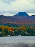
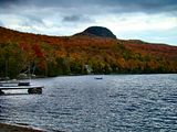
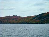
Lake Willoughby:
2009 South Beach -
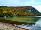
2010 North Beach -
2010 North Beach -
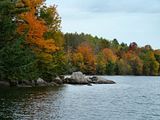
Long Pond (The one by Lake Willoughby) has a boat access that is a fairly easy drive from the shore north of Lake Willoughby up onto the mountain:
2010 Boat Launch-
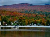
Crystal Lake (Barton):
2010 South Shore boat launch -
Round Pond/Long Pond (not the one by Lake Willoughby). This set of ponds is well hidden in a State Park almost no one has heard of

.
Round Pond is an easy 5 minute walk from the parking area:
2009 -
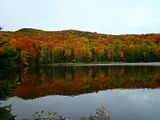
Long Pond (again not the one by Lake Willoughby) is another 10/15 minutes of more strenuous hiking past Round Pond:
2009 -
With a
very difficult 15 minutes or further hiking for the this picture location overlooking both ponds:
2009 -
Re: NEK (or other areas) ponds and lakes
Posted: Wed Sep 28, 2011 11:47 am
by ctyanky
NEK and Carol: great photos! You both are so talented!
Carol: If it were not for you I don't know if I would have ever gotten to Lewis Pond the first time! We had such a great time there with the gang! Can't wait to return!
Re: NEK (or other areas) ponds and lakes
Posted: Wed Sep 28, 2011 12:54 pm
by Andy
I'll add my two cents:
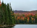
Kettle Pond from Owl's Head Overlook in the Groton State Forest October 2006:

Best in morning. Problem is that gate opens 9-10 and that's not the best. MrBumps posted elswhere here that the road is about a mile. It is all uphill, with some steep sections. He posted an early a.m. shot with his comments and it appears well worth the hike for those who are in good enough shape.
Unnamed Pond on U.S. 5 South of Crystal Lake (Barton), October, 2010:

This is a morning shot and is right next to the road. Park in the pull off and you can almost step into the pond
Ricker Pond on State Road 232 in Groton State Forest, October 2006:

There is a parking lot and an easy few steps to the pond. It is an afternoon shot.
Re: VERMONT PONDS AND LAKES
Posted: Wed Sep 28, 2011 1:00 pm
by Andy
I thought this was a great idea, Snookman, so I renamed it to "Vermont Ponds and Lakes" and made it a "sticky" thread. Hope we can keep it to the narrow topic of good ponds and lakes and directions to get there, etc.!


