State Tourism Report just released this morning September, 30th.
With the continued spell of warm and dry weather, color development has continued gradually throughout Vermont. Best colors continue to be in the northeast, where state foresters are reporting 30-40% of peak colors, dominated by yellows but with increasing proportions of orange and red in the mix. Elsewhere, there remains much green but reports indicate a steady, if gradual, progression, with colors remaining at about 20-30% of peak. With cooler air and showers visiting every corner of the state this week, we are already seeing an increase in the proportion of leaves changing colors and the intensity and brightness of those colors. We expect all parts of Vermont to be moving through early color and into mid-season conditions by the weekend. We remain on track and well-primed for great color into the early weeks of October.
Best Bets (North to South):
- Route 5A, from West Charleston through Westmore to West Burke.
- Route 16 from Barton to Westmore.
- Route 111 or 105 through Island Pond.
- Route 5 south from Barton to Orleans, then Route 58 to Irasburg.
- From Lowell, Route 100 south to Route 118 in Eden, then north to Montgomery.
- Route 242 from Montgomery to Jay.
It has been raining almost constantly since Tuesday afternoon. As of noon, it was still raining!
State Foliage Report issued on September 30th, 2015
Moderators: Andy, pwt54, admin, ctyanky
Re: State Foliage Report issued on September 30th, 2015
Hi,
This is great...
I am driving from South New Jersey to Vermont, due to tight schedule I am starting early morning and have get back by night....
Will try to go thru this routes and please let me know if there is a specific route I can do....
Loving to show the fall color to my parents before they travel back from US.
Thanks,
Rovin
-
From_the_NEK
- Posts: 377
- Joined: Wed Sep 16, 2009 9:39 am
- Location: Lyndonville, VT
Re: State Foliage Report issued on September 30th, 2015
Rovin,RovinRaj wrote:Hi,
This is great...
I am driving from South New Jersey to Vermont, due to tight schedule I am starting early morning and have get back by night....
Will try to go thru this routes and please let me know if there is a specific route I can do....
Loving to show the fall color to my parents before they travel back from US.
Thanks,
Rovin
Check out the "NEK Central" Route found here:
viewtopic.php?f=1&t=2008
This uses back roads to cover a lot of the area in the report above without being confined to main roads where traffic is driving 50+mph making slowing or stopping to enjoy views of the foliage difficult.
Re: State Foliage Report issued on September 30th, 2015
Hey, thanks for the details.
Will try to explore the section you mentioned and will come up with a route for tomorrow.
Me driving in a Sedan and is "http://goo.gl/maps/KHFa4" doable? as it is mentioned that there are few patches of Gravel roads in this route.
Will try to explore the section you mentioned and will come up with a route for tomorrow.
Me driving in a Sedan and is "http://goo.gl/maps/KHFa4" doable? as it is mentioned that there are few patches of Gravel roads in this route.
-
From_the_NEK
- Posts: 377
- Joined: Wed Sep 16, 2009 9:39 am
- Location: Lyndonville, VT
Re: State Foliage Report issued on September 30th, 2015
All of the roads on the "http://goo.gl/maps/KHFa4" route are easily drivable with a sedan. The sections of gravel roads are well maintained.
Re: State Foliage Report issued on September 30th, 2015
Thanks!
Will keep posted on my trip. This is my first Fall trip in US, hope to see the wonders the Lord has made.
Will keep posted on my trip. This is my first Fall trip in US, hope to see the wonders the Lord has made.
Re: State Foliage Report issued on September 30th, 2015
Hi NEK,
Sorry if i am bugging you with my questions,
Was trying to explore few places around and was able to get a route around 100, can you please let me know if this route makes sense for tomorrow.
https://goo.gl/maps/BokiNHYFW4x
Thanks,
Rovin
Sorry if i am bugging you with my questions,
Was trying to explore few places around and was able to get a route around 100, can you please let me know if this route makes sense for tomorrow.
https://goo.gl/maps/BokiNHYFW4x
Thanks,
Rovin
-
From_the_NEK
- Posts: 377
- Joined: Wed Sep 16, 2009 9:39 am
- Location: Lyndonville, VT
Re: State Foliage Report issued on September 30th, 2015
Since I'm in the northeastern part of Vermont, I can't really comment the colors in that area. However, that area north of Killington is a beautiful drive no matter what time of year it is.
-
colorchaser
- Posts: 11
- Joined: Wed Sep 30, 2015 4:01 pm
Re: State Foliage Report issued on September 30th, 2015
Planning to be in VT area on Oct 8,9,10.
Since I am traveling from west coast, I would like to know which locations would be the best in terms of peak colors for photography.
Tips and suggestions much appreciated.
Since I am traveling from west coast, I would like to know which locations would be the best in terms of peak colors for photography.
Tips and suggestions much appreciated.
-
deaner1971
- Posts: 449
- Joined: Wed Sep 03, 2003 12:01 am
Re: State Foliage Report issued on September 30th, 2015
Colorchaser,
In what part of Vermont will you be based?
It looks like folks are running the length and breadth of the state so, someone will have you covered.
In what part of Vermont will you be based?
It looks like folks are running the length and breadth of the state so, someone will have you covered.
-
From_the_NEK
- Posts: 377
- Joined: Wed Sep 16, 2009 9:39 am
- Location: Lyndonville, VT
Re: State Foliage Report issued on September 30th, 2015
Getting closer to peak up here in the central NEK, which is still probably 4-5 days away. Unfortunately that is when the hurricane is supposed to hit  . So this weekend I'm going to have to get after it if I want to get some good fall shots.
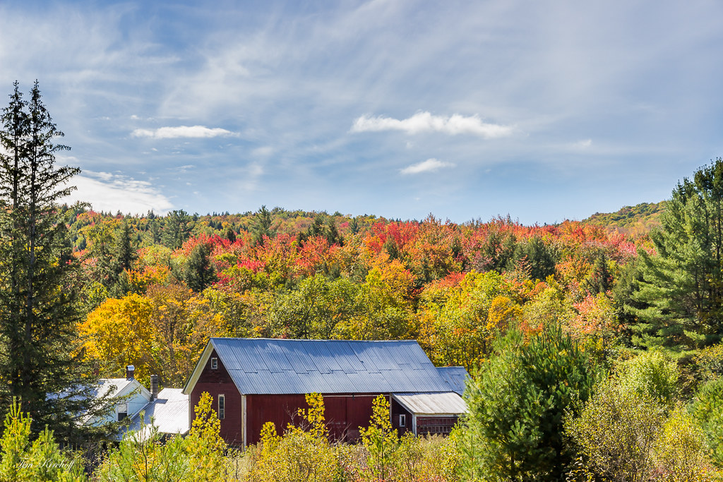
Last night on the Sutton side of Pudding Hill (part of the NEK Central route mentioned above) after work:
 Nearing Peak Foliage by Tim_NEK, on Flickr
Last night on the Sutton side of Pudding Hill (part of the NEK Central route mentioned above) after work:
Nearing Peak Foliage by Tim_NEK, on Flickr-
colorchaser
- Posts: 11
- Joined: Wed Sep 30, 2015 4:01 pm
Re: State Foliage Report issued on September 30th, 2015
I am planning to cover the entire state of Vermont ..I am new to the area..so will be going where the color draws me 
Any location hat tip with peak colors will be really useful for my trip
Any location hat tip with peak colors will be really useful for my trip
-
From_the_NEK
- Posts: 377
- Joined: Wed Sep 16, 2009 9:39 am
- Location: Lyndonville, VT
Re: State Foliage Report issued on September 30th, 2015
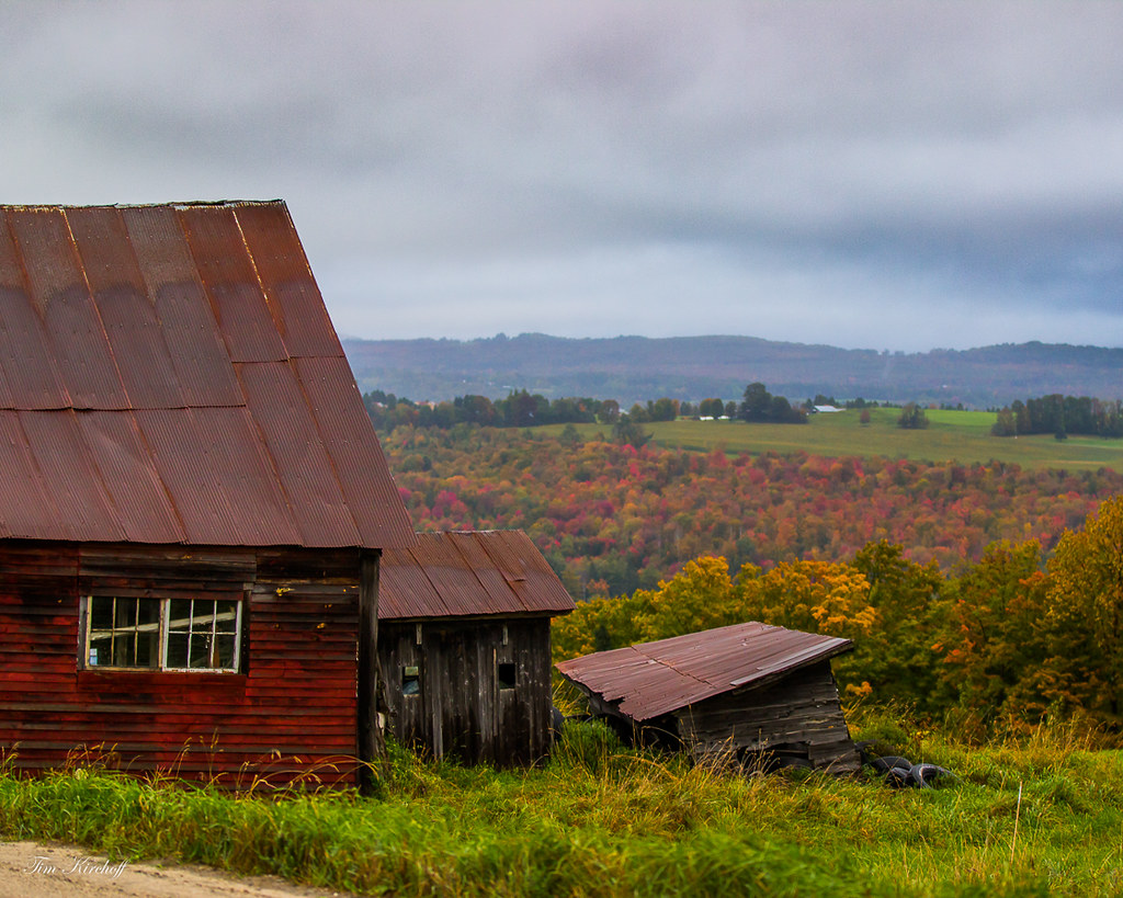
From today at lunchtime between Barnet and Danville.
There are pockets of near peak colors and then there are also a lot of trees that have a long way to go. Especially those along the edges of fields.
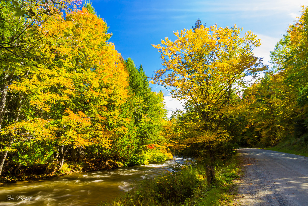 River Road by Tim_NEK, on Flickr
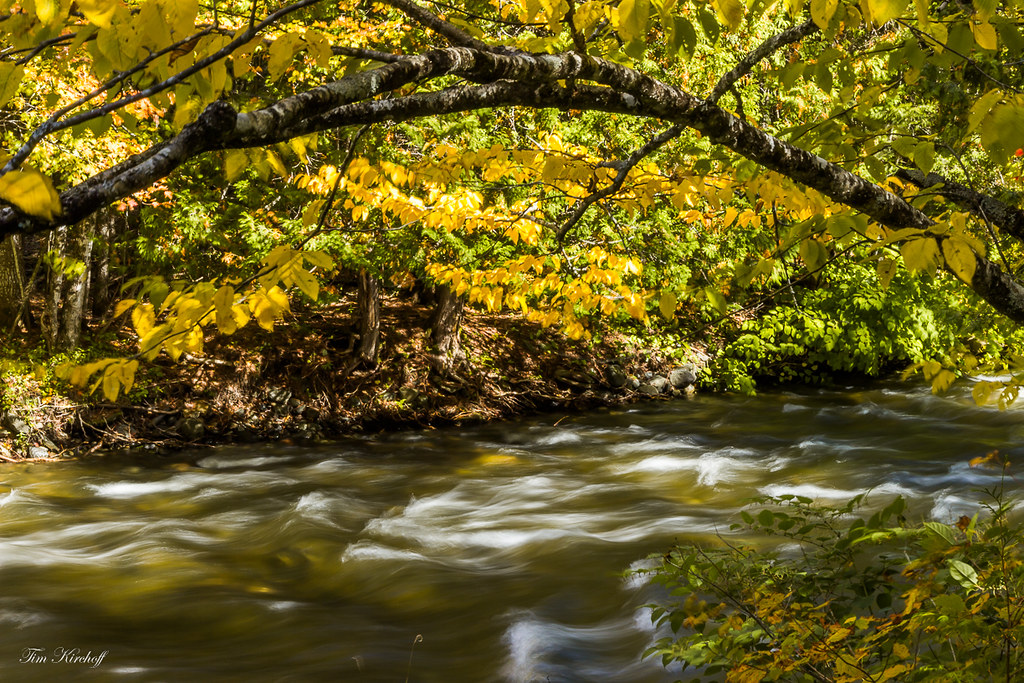 Yellow River Arch by Tim_NEK, on Flickr
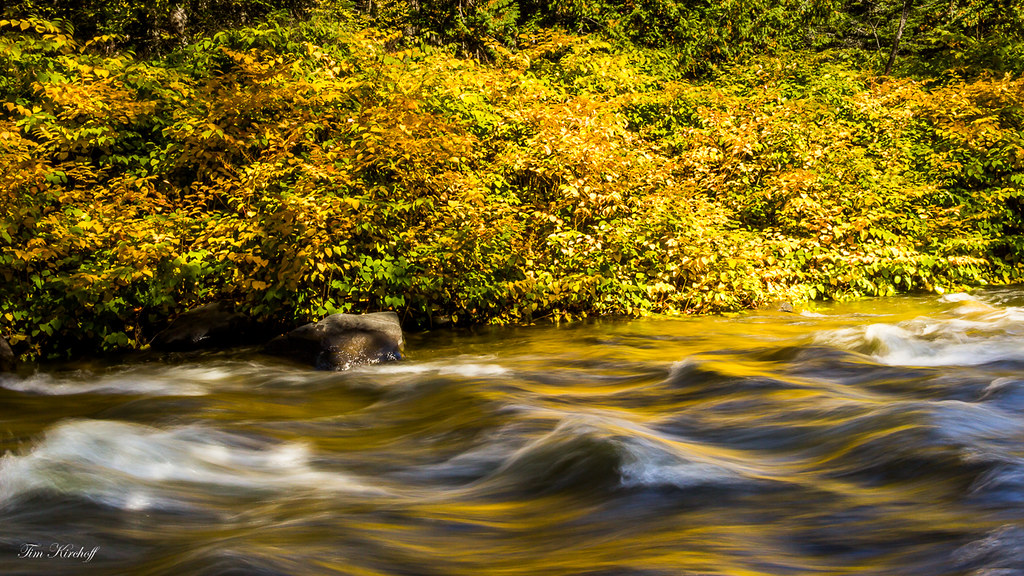 Yellow River by Tim_NEK, on Flickr
 Early Red by Tim_NEK, on Flickr
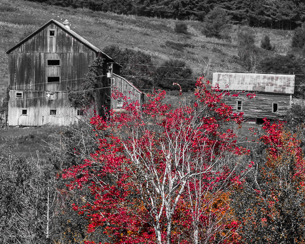
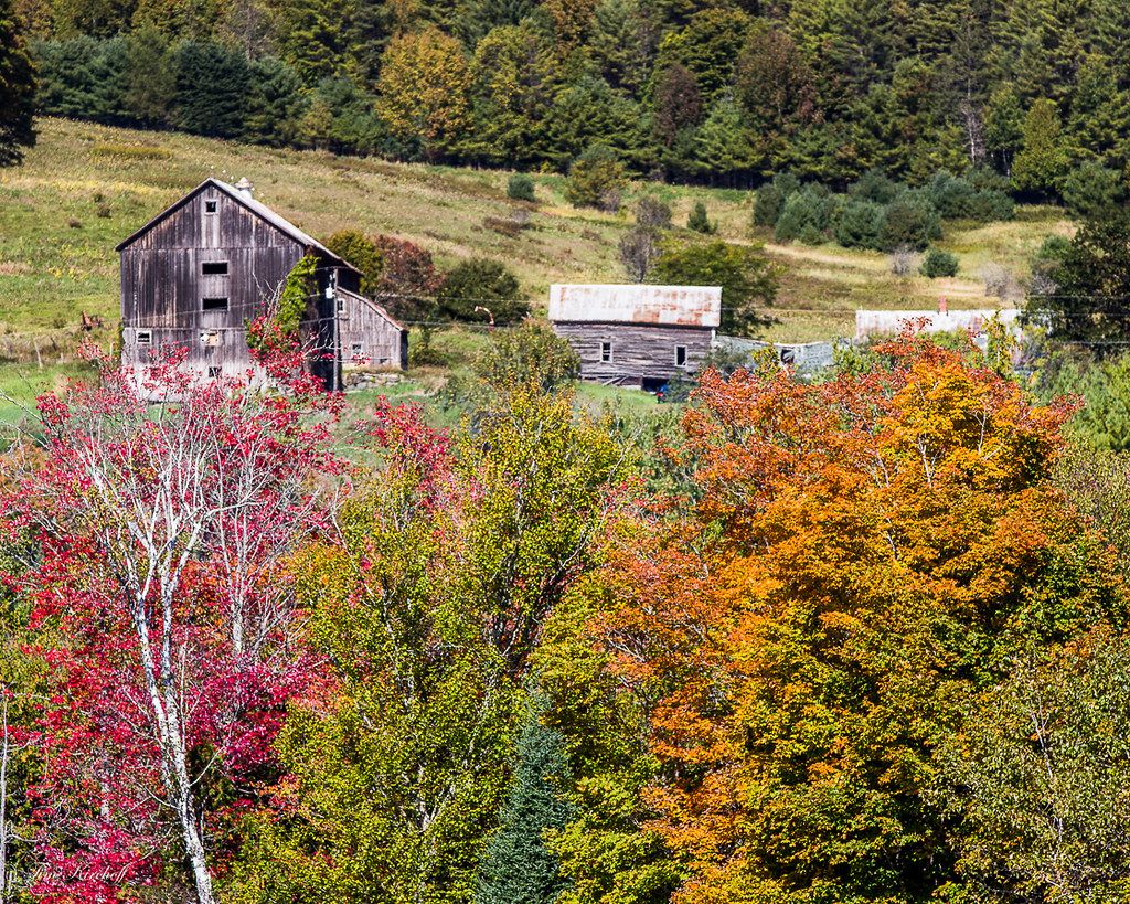 Hillside Farm by Tim_NEK, on Flickr
 Foliage Barn by Tim_NEK, on Flickr
There are pockets of near peak colors and then there are also a lot of trees that have a long way to go. Especially those along the edges of fields.
River Road by Tim_NEK, on FlickrYellow River Arch by Tim_NEK, on FlickrYellow River by Tim_NEK, on FlickrEarly Red by Tim_NEK, on FlickrHillside Farm by Tim_NEK, on FlickrFoliage Barn by Tim_NEK, on FlickrRe: State Foliage Report issued on September 30th, 2015
Thanks for the pix, they are worth 1000 words each as you know. I like that last one. But boy, it really is way late this year!
Interestingly it has been cloudy all day here down south and nice up there, glad you got to enjoy the day.
Interestingly it has been cloudy all day here down south and nice up there, glad you got to enjoy the day.
Charles Kozierok - DesktopScenes.com
View Autumn Scenes from Southern Vermont (2003), my free, 75-image foliage gallery!
View Autumn Scenes from Southern Vermont (2003), my free, 75-image foliage gallery!
Re: State Foliage Report issued on September 30th, 2015
I drove around the NEK today. Drove up from Lebanon, NH. St. Johnsbury looked good from 91, btw. I went up Route 5 in Lyndonville to 114E, then Darling Hill Rd, which had some good views, probably abou 50% turned, still quite a bit of green. Next it was Burke Hollow Rd, Sugarhouse Rd, Newark St. then onto rt. 5A up to Willoughby Lake. Some color, but it has a long way to go. A good week at least. Next 16W, some nice color along there. Eventually I took Burton Hill Rd to Irasburg. Then I went up 14N, 58W, 100N, N. Hill Rd upt o 242W and on up to Jay Peak Resort. Nice color along the way. Some spots higher color than others. Next weekend should be better. Jay Peak had color at the lower elevations believe it or not. Higher up, not as much. From there continued on 242W to 118 S. Great color along this route. Went to Belvedere Pond on 118, really nice. Too bad it was so windy and it made the water rough, spoiling any chance for reflections. Backtracked to 109s, again real nice color down this road. Hung a left onto Hog Back Rd and a lot of nice color and mountain views along this road. It end on Rt. 15 and I took that east. All along 15 was really good color, probably 60-70%.
Turned down 215S and lots of nice color there as well. Briefly took 2E to 232 South and Groton State Park. Hiked up to the Owl's Head lookout. Nice color down there, but may 50% turned. Another week and it will be great. Nice color at the ponds and Lake Groton, too. Really bright reds, oranges and yellows along 232 as well. Took 302 back to 91, some nice color on 302, but was getting kinda gloomy out by then.
Kinda wishing I had done this route next weekend. Probably will be more colorful. But with the weather reports so up in the air yesterday, I decided I'd better take a shot now just in case the hurricane spun our way. So, I spent most of my day north of Rt. 2 but I think it still has some more to go. I'll bet it's good up there for the next 2 weeks barring any major wind or rain.