First of all, a caveat. I'm just outside Dallas, TX...not sitting in a Vermont weather service office.
But I do know how to ferret out weather info - and here's what I've found. After Hurricane Joaquin formed, most computer forecast models had it eventually hugging the east coast and grazing the eastern edge of Virginia. But one model, the European, was the outlier. It kept Joaquin off the shoreline by 100-200 miles then took it out to sea instead of running it up over Long Island and straight into New England. You need to know that of all the models, the European may be the most respected. It does make mistakes, like all models, but it does a really good job most of the time.
This morning, the models that WERE calling for Joaquin to hug the shoreline have jumped on the European bandwagon and pretty much adopted their ideas. Now it must be said that of all meteorological creatures, the hurricane is the hardest to predict...and is very fickle. So even though there is more of a consensus this morning, that doesn't mean Joaquin will do what they say. But it is a good sign for those of us who will be in Vermont next week.
I've been tracking the White River Junction/Hanover forecast. This morning there is a bit less rain in the forecast. In fact, Sunday's forecast currently has no rain in it. The forecasters have admitted that they are waiting for more Joaquin data before they can nail down next week's forecast with any certainty.
So, if Joaquin behaves, things are looking up. I hope to have time this evening (late) to update things.
Oct. 1 weather update
Moderators: Andy, pwt54, admin, ctyanky
-
Rockwall Tim
- Posts: 154
- Joined: Sun Apr 05, 2009 4:43 pm
- Location: Rockwall, TX
- Contact:
Oct. 1 weather update
II Cor. 4:17
-
fallingforcolors
- Posts: 8
- Joined: Mon Sep 14, 2015 9:33 pm
Re: Oct. 1 weather update
Tim, like you I'm also watching this closely. I'm flying to Manchester(MHT) on Monday morning. 3 days in VT and 2 days in NH is the plan..My question for seniors in this forum, When they talk about storm hitting NE coastal areas how far does it extend westward. For e.g what's the impact if you are in Conway, NH or White mountains? I believe there won't be a problem in VT. Since I haven't traveled here can't visualize much. Thanks. This is the only forum I'm able to find some good information to make informed decision 
Re: Oct. 1 weather update
Away from the coast the biggest impact is rain. That's what caused nearly all the devastation with Irene.
Inland winds can be strong but as soon as a storm hits land its winds immediately drop down and usually it is not any more windy than any other big storm. There are hurricanes that carry very strong winds 100+ miles inland but they are very rare (and this is not likely one of them).
Inland winds can be strong but as soon as a storm hits land its winds immediately drop down and usually it is not any more windy than any other big storm. There are hurricanes that carry very strong winds 100+ miles inland but they are very rare (and this is not likely one of them).
Charles Kozierok - DesktopScenes.com
View Autumn Scenes from Southern Vermont (2003), my free, 75-image foliage gallery!
View Autumn Scenes from Southern Vermont (2003), my free, 75-image foliage gallery!
-
Rockwall Tim
- Posts: 154
- Joined: Sun Apr 05, 2009 4:43 pm
- Location: Rockwall, TX
- Contact:
Re: Oct. 1 weather update
BTW, the noted meteorologist and hurricane expert, Joe Bastardi, is calling for Joaquin to head out to sea as well.
I'm getting more and more encouraged about sunshine next week. The attached graphic is from the European model's cloud cover forecast. It is its prediction of cloud cover at 1 pm Sunday...obviously the white area represents cloudiness, the dark area equals sunshine. I checked Monday and Tuesday as well - and they showed more sun than clouds.
I'm trying not to get too excited.
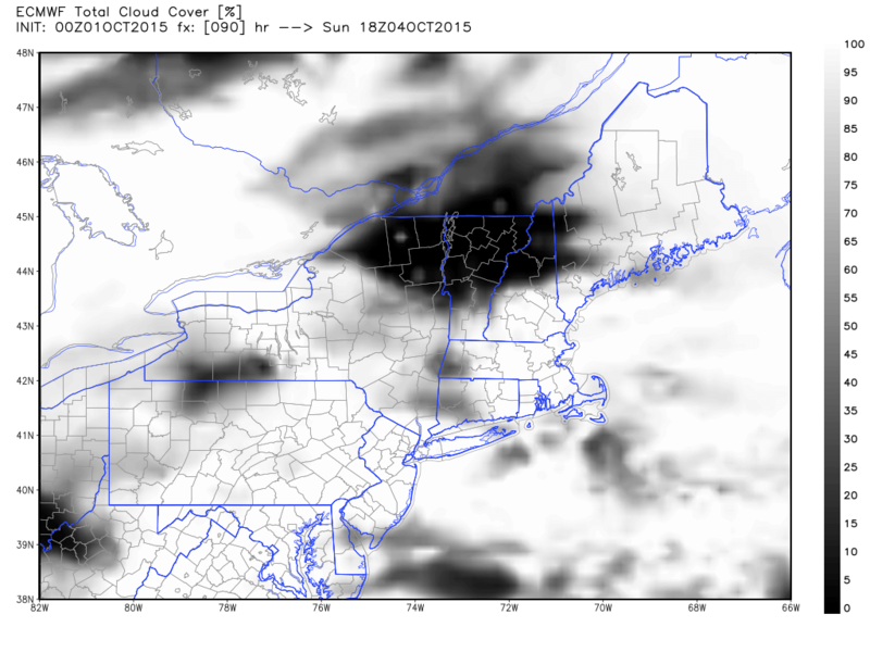

II Cor. 4:17
Re: Oct. 1 weather update
NWS Burlington going with a dry forecast and little/no impacts from Joaquin :
NATIONAL WEATHER SERVICE BURLINGTON VT
354 PM EDT THU OCT 1 2015
.SYNOPSIS...
A LARGE AREA OF HIGH PRESSURE ANCHORED ACROSS ONTARIO AND QUEBEC
WILL PROVIDE COOL AND DRY NORTHERLY FLOW TO THE NORTH COUNTRY
THROUGH AT LEAST SATURDAY. THERE WILL BE SOME CLOUDS AT TIMES
ALONG WITH SEASONABLY COOL TEMPERATURES. WILL SEE SOME FREEZING
TEMPERATURES IN THE ADIRONDACKS AND FAR NORTHEASTERN VERMONT LATE
TONIGHT...AND LIKELY AGAIN ON FRIDAY NIGHT.
&&
.NEAR TERM /UNTIL 8 AM FRIDAY MORNING/...
AS OF 350 PM EDT THURSDAY...COLD FRONT HAS PUSHED WELL SOUTH AND EAST
OF NEW ENGLAND WITH NORTH COUNTRY FIRMLY ENTRENCHED IN SEASONABLY
COOL AIR MASS. WHILE A DRY NORTHERLY FLOW REGIME PREVAILS AT LOW-
MID LEVELS...THE UPPER LEVEL FLOW REMAINS SOUTHWESTERLY...ALLOWING
FOR CIRRUS CLOUDS TO STREAM NORTHEAST FROM OHIO VALLEY AND MID
ATLANTIC STATES. SOME CIRRUS WILL REMAIN OVER THE REGION
TONIGHT...BUT WILL NOT BE ENOUGH TO PREVENT TEMPS FROM FALLING
INTO THE UPPER 20S AND 30S. FREEZE WARNING REMAINS IN EFFECT FROM
06-12Z FRIDAY FOR THE ADIRONDACKS...NORTHERN FRANKLIN NY
COUNTY...AND ALSO ESSEX COUNTY VERMONT. THIS WILL GENERALLY BE AN
ADVECTIVE COLD...WITH WINDS REMAINING NORTH TO NORTHEAST AT 5-8
MPH AT TIMES OVERNIGHT AND THE HIGH CIRRUS CLOUDS IN PLACE. THESE
FACTORS WILL PRECLUDE MUCH IN THE WAY OF FROST...BUT AIR MASS AND
MOS GUIDANCE SUPPORTS FREEZING TEMPS (25-32F) AND ASSOCIATED
FREEZE WARNING IN ABOVE MENTIONED ZONES. LOWS ELSEWHERE GENERALLY
IN THE MID 30S...SO ONE OF THE COLDER NIGHTS OF THE SEASON FOR
MOST PORTIONS OF THE NORTH COUNTRY.
&&
.SHORT TERM /8 AM FRIDAY MORNING THROUGH SATURDAY NIGHT/...
AS OF 350 PM EDT THURSDAY...SHORT-TERM PORTION OF THE FORECAST WILL
FEATURE LITTLE CHANGE WITH CONTINUED DRY CONDITIONS WITH HIGH
PRESSURE IN CONTROL AND CENTERED WELL TO OUR NORTH ACROSS
QUEBEC/ONTARIO. BREEZY NORTHERLY WINDS EXPECTED AGAIN ON
FRIDAY...GENERALLY 10-20 MPH WITH SOME GUSTS 30 MPH IN THE BROAD
NORTHERN VALLEYS. STAYED CLOSE TO MOS CONSENSUS ON TEMPS WITH
VALLEY HIGHS IN THE MID 50S FRIDAY AND SATURDAY. WILL LIKELY SEE
SOME ADDITIONAL FREEZING TEMPERATURES IN THE ADIRONDACKS AND THE
NORTHEAST KINGDOM ON FRIDAY NIGHT. A BIT MORE CLOUD COVER FOR
SATURDAY AFTERNOON/NIGHT WILL RESULT IN MIN TEMPS FRIDAY NIGHT A
COUPLE OF DEGREES MILDER WITH LOWS IN THE MID 30S TO AROUND 40.
POPS ESSENTIALLY NIL THROUGH THE PERIOD...ALTHOUGH AS FLOW TURNS
MORE EASTERLY LATE IN THE PERIOD THERE IS JUST A SLIGHT CHANCE FOR
A FEW LIGHT SHOWERS SOUTH.
&&
.LONG TERM /SUNDAY THROUGH THURSDAY/...
AS OF 325 PM EDT THURSDAY...AFTER SEVERAL DAYS OF MODEL
DISAGREEMENT IN REGARDS TO THE OVERALL TRACK AND IMPACT OF
HURRICANE JOAQUIN ON THE EAST COAST, TODAYS 00Z AND 12Z RUNS HAVE
ALL COME IN LINE. GOOD NEWS IS THAT EVERY MODEL EXCEPT FOR THE
CANADIAN GEM HAS TRENDED TO THE ECMWF SOLUTION, KEEPING JOAQUIN
WELL OFFSHORE WITH LITTLE TO NO IMPACTS EXPECTED AT THIS TIME.
WHAT THIS MEANS FOR THE NORTH COUNTRY IS ANOTHER EXTENDED PERIOD
OF DRY CONDITIONS FROM SUNDAY THROUGH TUESDAY AS HIGH PRESSURE
ANCHORED OVER CENTRAL QUEBEC DOMINATES OUR WEATHER. IN GENERAL,
WE`LL SEE PARTLY SUNNY/CLOUDY SKIES WITH NEAR SEASONAL
TEMPERATURES, HIGHS IN THE 60S, LOWS IN THE 40S.
ONLY CHANCE FOR PRECIP, ALBEIT A LOW ONE, WILL BE TUESDAY NIGHT
THROUGH WEDNESDAY AS AN UPPER TROUGH AND WEAK EMBEDDED SHORTWAVE
ENERGY PASS THROUGH THE NORTHEAST. OVERALL DYNAMICS ARE WEAK AND
LACKING IN DEEP LAYER MOISTURE, SO ONLY LOOKING AT LOW CHANCE
POPS, FOLLOWED BY ANOTHER AREA OF STRONG HIGH PRESSURE BUILDING
BACK INTO THE REGION FOR THURSDAY.
-
Rockwall Tim
- Posts: 154
- Joined: Sun Apr 05, 2009 4:43 pm
- Location: Rockwall, TX
- Contact:
Re: Oct. 1 weather update
New 4 p.m. forecast on Oct. 2 calls for mostly sunny daytime skies Sunday through Wednesday for sure...and the rest of the week looks good, too.
II Cor. 4:17
Re: Oct. 1 weather update
Have a wonderful trip Tim! You hit it right for the big show! Just what you prayed for. I'm so happy for you! Enjoy your blessed time in Vermont! 