Page 10 of 11
Re: Best scenic views/Must see spots
Posted: Wed Aug 29, 2012 7:31 pm
by ctyanky
Hi SOV viewers: I have made MMVT's post for "Best Scenic Views/Must See Spots" a sticky because there are some excellent resources in this post that will be of value to you for this upcoming foliage season. I hope you can scroll through some of the responses for some great roads with long views and so on. There were some terrific contributions! Enjoy!

5 Fall Foliage Drives in Addison County
Posted: Mon Sep 03, 2012 6:43 pm
by ctyanky
Hi everyone: I was going through my "VT Book Bag" sorting and sorting for the upcoming trip and found the Addison County Independent Fall Foliage Special Section from 2011 that bm gave me last year. I thought it was excellent and by googling for a bit, I found the five drives online to share with all of you. bm, our moderator direct from Addison County, has taken me on so many of these roads at different times and sections. Addison County is absolutely gorgeous! I am very fortunate that bm has become such a good friend of mine and we have tooled around the countryside of her county many times! It may be that the foliage in these drives changes a tad later due to the close proximity of Lake Champlain. Maybe she will chime in with comments at some point but I hope you enjoy the link and the drives, designated by the time it takes to complete the route: 1, 2, 3 or 4 hours or a day trip. Enjoy!
It was entitled
"Discover Addison County's Back Road Splendor".
http://www.addisonindependent.com/?q=node/2807
Re: GREAT VERMONT DRIVING ROUTES
Posted: Fri Sep 14, 2012 11:49 am
by wentworth
yeah, we like the 2 gap roads also, lincoln gap rd and Rt. 125
Re: GREAT VERMONT DRIVING ROUTES
Posted: Fri Sep 14, 2012 11:57 am
by wentworth
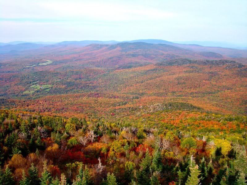
Rt 232 going north, from Rt 2, in late S ept2010 it was a beautiful sight, then to Owl's Head, and that quick hike to see K ettle Pond from way up high--beautiful--great color everywhere
Re: GREAT VERMONT DRIVING ROUTES
Posted: Tue Oct 02, 2012 8:59 pm
by Aspen
Http://www.Foliage-vermont.com has some outstanding printable maps and driving directions. Upon getting to this site, check the column on the left side for tabs. Click on: Driving tours.
There will be a list of some planned, great maps and driving directions for the following areas of Vermont:
Favorite Highway routes
Northeast Kingdom
Covered bridges tour in Northern Vermont
Lake Champlain Area
South Central Vermont
Quechee-Woodstock area
Biking Tours
Happy rolling along,
Aspen
Re: GREAT VERMONT DRIVING ROUTES
Posted: Fri Aug 23, 2013 10:00 am
by sharan
On Page 3 of this thread, "Mountain Rd(rt 108)Attractions from Stowe"Aspen talks about Brook Rd and a covered bridge. Can anyone tell me where that is? I can't find it in my atlas or in the Barna Covered Bridges book. Thanks.
Re: GREAT VERMONT DRIVING ROUTES
Posted: Fri Aug 23, 2013 6:59 pm
by ctyanky
Sharan: It's probably Emily's Bridge on Gold Brook Road. Check it out in Barna's.
http://www.virtualvermont.com/coveredbr ... milys.html
Re: GREAT VERMONT DRIVING ROUTES
Posted: Tue Aug 27, 2013 3:21 pm
by From_the_NEK
Scenic Drive, DRIVING ROUTE - New for 2013, NEK Southeast!
Google Directions:
Full Loop:
https://goo.gl/maps/YmicVUWLBps
Victory Bog Option:
https://goo.gl/maps/bMf87Bbeu7B2
Both options are about 3.5 hrs non-stop
Including Stopping to take pictures... maybe 3 days

The east central part of the NEK is dominated by Victory Basin and the two mountain ridges that surround it (Burke/Kirby Mtn ridge and Stone-Miles Mtn ridge). These physical feature and the general lack of population make for a relative lack of good (decent to drive on) roads in the area. US Route 2 bisects a good portion of this area as well.
This route also covers a lot of different elevations, from Lyndonville (700') to the top of the pass of the Kirby Mtn Rd (1700'), back down to the banks of the CT River (850') and back up to the top of the Victory Rd (1900'). So somewhere in that range, you should find some good color

.
Starting again at the Colonnade Inn in Lyndonville, just off of I-91 Exit 23.
Highlights include East Kirby. Shadow Lake (Concord), East Concord, Lunenburg, Neal Pond, CT River Valley, White Mtn views, Victory/Granby Rd. Burke Mtn, Ridge Rd.
This route takes you to the Mid-Burke Lodge area on Burke Mountain and past the entrance to the Toll Road that goes to the top. I recommend the Toll Road and the Fire Tower if you have a very clear day.
The Victory Bog Option bypasses going all the way to Guildhall in favor of going through the heart of Victory Bog between North Concord and Gallup Mills. Adding this road sort of cuts the region in half. I HIGHLY recommend driving through the bog if you get a chance.

You can also add the River Rd/Victory Rd driven as an option to the full loop. When driving the Full Loop, you will encounter the north end of Victory Rd when you go through Gallup Mills. It is about a 10 mile drive to the other end in North Concord. Once you hit Route 2, turn around and drive back to Gallup Mills. This way you have twice the chances of seeing a moose!

I also left Waterford out of this route do to its isolation South of I-93. I should create a short driving route in that area as well for those with a short time window.
Note: There are very few towns along this route. Lancaster, NH is easily the biggest, just across the CT river on Rt 2. This would probably be a good place to stop for lunch, rest rooms, etc.
Re: GREAT VERMONT DRIVING ROUTES/Rte 108/Brook Rd Covered Br
Posted: Sun Sep 08, 2013 6:37 pm
by Aspen
So nice to see the Scenes of Vermont Fall Foliage Forum active with folks making plans for another Autumn of exploring and enjoying, beautiful Vermont!
This is in reference to Sharan's inquiry where the Covered Bridge is located off of Route 108 in Stowe.
It is not Emily's Covered Bridge. Emily's Covered Bridge is over off of Route 100.
Emily's Bridge is also a nice covered bridge to visit when in the Stowe Hollow area.
On the page 3 thread which I shared of different places to enjoy
along Route 108, several Autumns ago, there was this nice covered bridge off Route 108 on Brook Road which was very easy to miss. If anyone comes up with the name of this particular covered bridge, add it to this thread for the Route 108/Mountain Road drive.
Drive on Route 108/Mountain Road
As you pass Edson Hill Road which will be on your right side, watch for Brook Road coming up on your left.
(Landmarks: TopNotch Resort & Spa will be on right side of 108; if you pass Innsbruck Inn on your left, you missed Brook Road)
Turn left onto Brook Road from Route 108
On left side of Brook Road, there is a Recreation Path Parking lot. Park at the parking lot. Walk down Brook Road to
the Covered bridge.
Again, want to share that Route 108 is jam packed with so many things to see and do while in Stowe. Route 108 concludes with that
MUST experience drive through Smuggler's Notch!
Keep on driving on Route 108 until you arrive to Smuggler's Notch.
Aspen
Stowe Recreation Path Map Addendum: 9/17/13
Access to finding a map of the Stowe Recreation Path is below:
Go to
http://www.gostowe.com
On
Stowe Homepage, click on the
Stowe Foliage Central box
Scroll down to end to
Scenic Drives
Click on Jeffersonville/Johnson, Hyde Park DRIVE
Directions will appear for the Drive. LOOK over to the PLAY column on left side
Scroll down,
click on Recreation Path
On the Stowe Recreation Path page, there will be a map on the right side
Click on the Recreation Path Map to enlarge it.
This map shows how the Stowe Recreation Path and Route 108 parallel
The Covered Bridge is visible on Brook Road on this Recreation Path map
Aspen
Re: GREAT VERMONT DRIVING ROUTES
Posted: Mon Sep 09, 2013 8:30 pm
by sharan
Thank you Aspen. Covered bridges are one of my favorite things in Vermont!
Re: Stowe: Popular Driving Routes update
Posted: Tue Sep 10, 2013 11:50 pm
by Aspen
Access to information on eleven of GoStowe's great driving routes in and nearby Stowe, Vermont has been updated on the Great Vermont Driving Routes thread. Go to page 3, look for topic: Stowe: Popular Driving Routes.
Aspen
Re: Belted Cows
Posted: Sat Sep 28, 2013 2:18 am
by Aspen
With stories filtering into the Foliage Forum that the colors in the Northeast Kingdom are approaching peak, many leaf peepers will be heading to the Northeast Kingdom this weekend and within the next few days. Some familiar with the Northeast Kingdom have suggested driving Darling Hill Road in Lyndonville, Vermont. For those who may be driving along Darling Hill Road, keep an eye out for belted cows grazing in the pastures of Meadow View Farm. If you have never seen a belted cow, this may be your opportunity. Belted Galloway cows are a special sight to behold.
Several Autumns ago, there was an exciting discussion on this Forum about the Galloway belted cows that may be found on some farms in Vermont. We drove past the Diamond Heart Farm in the Northeast Kingdom in Irasburg where we saw out first belted cows. There were black cows with white belts and also brown cows with white belts. The cows looked like their white belts had been painted on them. It's a special sight and wonderful picture op to experience seeing the belted cows grazing in the pastures. Belted cows may be found in other towns of Vermont. Once we saw our first ones, we could easily recognize them on other farms.
You may be assured that seeing these special belted cows for the first time in such a beautiful Autumn setting will moo-ve you!
Aspen
Jeffersonville/Cambridge: Pleasant Valley and Bryce Road
Posted: Fri Oct 04, 2013 2:41 pm
by DGehman71
[Edit: Forgot to acknowledge the source. The people at Visions of Vermont, a great gallery on Main Street in Jeffersonville, turned us on to this route.]
After you've trekked from Stowe to Jeffersonville via Smuggler's Notch via Route 108, you'll reach a Y. Bear left onto Church st. (if you bear right, you're on Main st., with the exceptionally good Alden Bryan and Visions of Vermont galleries). Turn left at first road, Upper Pleasant Valley Rd.
Follow Upper Pleasant Valley Rd. SW a little more than 2 1/10 miles to Bryce Road, a dirt road to the right.
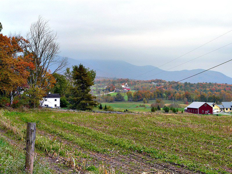
Follow Bryce road to its high point (there's a large farm perched there), stop and look back at the vista that includes Mt. Mansfield and several picturesque Vermont farms and structures.
Continue on Bryce which (Oct. 2, 2013) is very well maintained to Lower Pleasant Valley Road.
Turn left on Lower Pleasant Valley Rd. Many pleasant views of the highlands to your left where Bryce Rd. runs. Follow to the first stop sign -- which is Upper Pleasant Valley Rd.
Then either turn left back to Jeffersonville, or right to Underhill Center, with (when the road reaches King Rd.) one of the most pleasant country stores/delis ever, the Underhill Country Store. Great sandwiches and service.
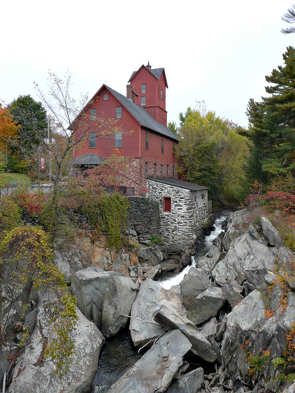
Right on King takes you to Route 15 (where a right turn heads you back to Cambridge & Jeffersonville; a left turn lead you to Jericho and The Red Mill.).
Re: BEST SCENIC VIEWS/MUST SEE SPOTS!
Posted: Mon Oct 07, 2013 4:31 pm
by scurtis623
We went up to Northeast Kingdom Oct. 2 & 3. Took the tour someone posted here with google map, starting at Lyndonville, north Pudding Road, Lakeview Road, across top of the Lake, up Hinton Rd, then south on 114. Tue it was very cloudy, you could see color but it needed SUN! Beautiful colors on 114.
Wed AM we went back up on 114, it was very nice. Then did the loop around Danville, Peacham, Groton etc. It was OK.
Coming home we went over to Littleton I-93, just before Fanconia Notch it was fantastic!! OMG OMG. Best color with blue skies, & sun.
We've been going up in this area for the past 30 years, so we've seen some wonderful sites and some bad years. I love this forum for all the great up to date info and giving driving directions.
Re: VERMONT WATERFALLS
Posted: Mon Sep 15, 2014 4:32 pm
by fallguy
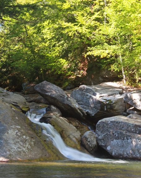
For the past few years I have made probably three tries to find Pikes Falls, appropriately just off of Pikes Falls Road. I hate wasting prime foliage time in these misadventures so this weekend I made one final attempt. Success!
I diligently tried to follow website directions but could not locate it. It is 4.8 miles from the intersection of route 30 and Pike Falls road in Jamaica. The main reason for finding this set of falls is that it appears there are several deciduous trees to provide fall color.
- PF01.jpg (180.2 KiB) Viewed 65312 times
There are several composition choices to make this site even more appealling, but the effect of the sun limits prime image taking to cloudy or pre sun rise times.

- PF04.jpg (153.3 KiB) Viewed 65312 times
As you can see the falls are not giants. On the plus side because of the narrow slide it may not need a recent rainfall to stay active.
